Early LNG Carrier Passage for LNG Canada
As part of the start-up procedures for the LNG Canada project in Kitimat, a single fully loaded LNG Carrier is expected to arrive in or around Monday March 31st to Tuesday April 1st.
More specific dates and times will be posted Monday morning or when provided by LNG Canada.
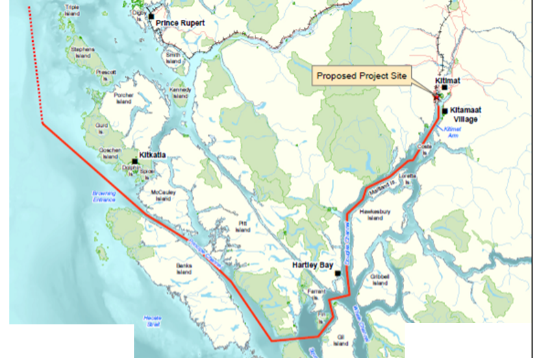
The vessel MARAN GAS ROXANA (IMO 9701229, MMSI 241415000) will be transiting on the outside of Porcher Island, and through Principe Channel
While the full operation of LNG Canada is not expected until later in the summer, the Nation has been preparing for LNG shipping, including the following programs:
- Monitoring for effects on shorelines and harvesters from wake and noise
- Preparing for accidents through geographic response planning
- The implementation of Waterway Management Guidelines
(More details for each of these projects are attached to this notice)
Concerns can be raised to staff at the Gitxaała Territorial Management Agency
https://www.lngcanada.ca/news/community-notification-lng-import-cargo-delivery/
GTMA/ LNG Canada Wake Monitoring Bouy
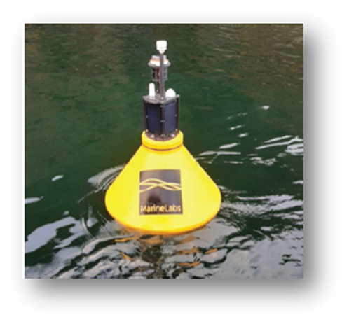
In order to monitor the effects of vessel wake, Gitxaała Territorial Management Agency has been involved with the placement of “Wake Monitoring Buoys” managed by MarineLabs.
The buoys are deployed in 9 areas along the LNG Canada shipping route to collect wake monitoring data to verify the management policies designed to reduce the impact of ship wake on Gitxaala harvesters and shorelines. Please see the Attached Bulletin for more information on the buoys.
Approximate location of the buoys is in the following table.
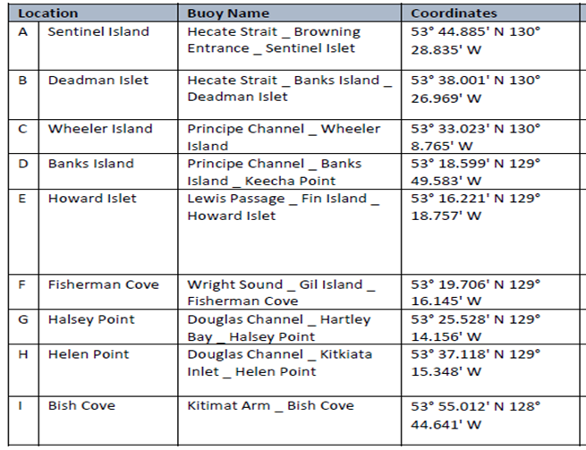
Locations are general, Any boat users are advised to use caution when transiting these areas and keep a watch. If any are spotted in different locations, or floating free, please avoid it, and report location to the GTMA office (250-624-3339), Guardians or at the Band Office.
Geographic Response Planning
Geographic Response Planning is a tool for communities to prepare for marine emergencies and shipping incidents including oil spills. Having plans in the event of a marine incident saves time by giving responders a plan they can put into place immediately, before valuable areas and resources are impacted following a marine shipping incident.
Areas of Concern and Geographic Response Strategies
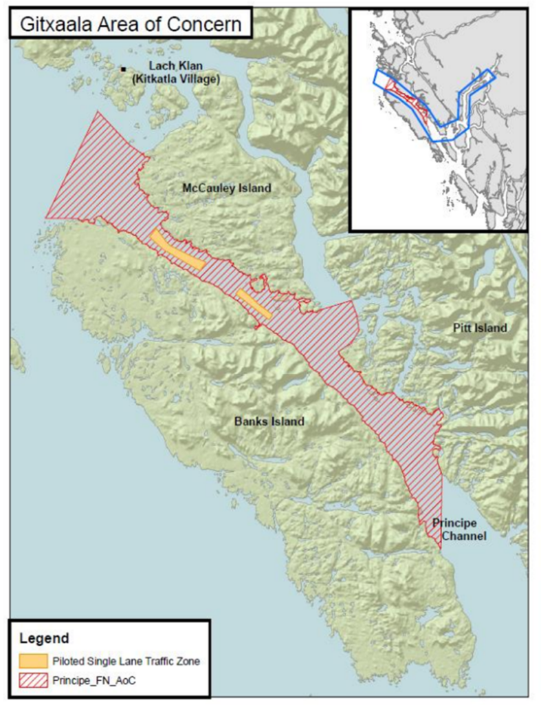
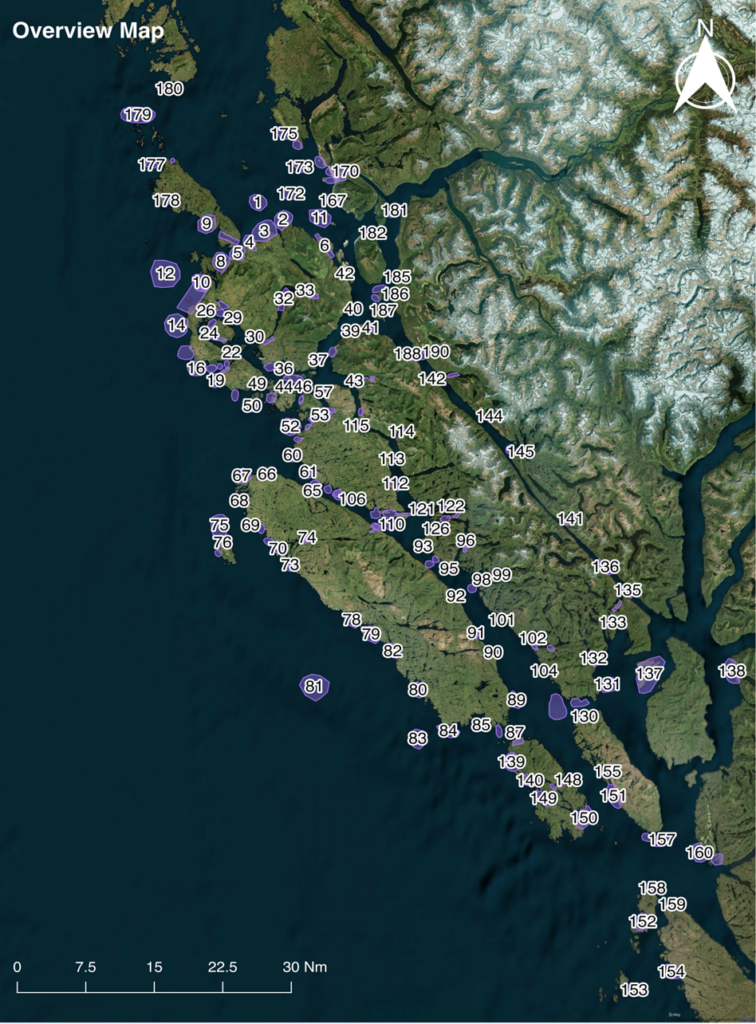
In 2019, Gitxaała community members, as part of an advisory group, identified almost 200 Areas of Concern in Gitxaala Territory – areas of social, cultural ecological, or commercial value that are particularly sensitive and vulnerable to pollution (Figure 1).
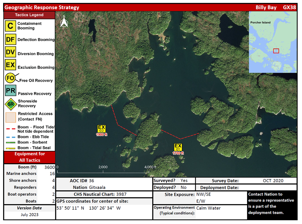
Tactical plans, called Geographic Response Strategies, are being developed for every Area of Concern. To date, 63 Geographic Response Strategies have been completed. These Strategies are for responders and detail how to protect resources or a location within an Area of Concern in the event of a marine incident. The strategies also outline the type of equipment required and location specifics such as GPS coordinates, navigational or safety hazards, site exposure, and the operating environment (Figure 2).
Geographic Response Strategy development is not meant to replace prevention. Geographic Response Strategies are developed ahead of time to help responders to take protective measures quickly following a marine incident. During a major marine incident, it may not be possible to protect or save every valuable area or resource that is at risk. It is always preferable to focus on mitigation activities that prevent an incident from occurring in the first place.
Gitxaala Territorial Response Plans
In conjunction with the Geographic Response Strategies, a Gitxaała Territorial Response Plan was drafted for use by Gitxaała personnel, marine response partners, and responders in the event of a marine pollution incident in Gitxaała Territory. It provides information to guide the actions of Gitxaała Nation in response to a marine pollution incident and to inform other government and industry stakeholders who may engage in spill preparedness and response activities in Gitxaała Territory.
GTMA- Vessel Management
As part of on-going work on vessel management, through a project called “Proactive Vessel Management”, GTMA staff have worked with Transport Canada (TC) and Gitga’at First Nation as well as other key stakeholders to deliver improved and enhanced management of marine traffic issues and to improve safety on the water by reducing conflicts between First Nations’ marine use activities, such as fishing and shoreline harvesting
The resulting guidelines direct best practices for commercial vessels navigating between Kitimat and Browning Entrance via Douglas Channel, Wright Sound, Lewis Passage, Otter Channel, Nepean Sound and Principe Channel. The guidelines include First Nations Areas of Concern for areas where a higher level of care is required to ensure safe transits. The Gitxaala Area of Concern is in Principe Channel.
The guidelines contain information for:
- All vessels that covers:
- inshore safety zones
- routing measures
- speed reductions
- guidelines for meeting and passing
- a special operating area in Wright Sound, and
- guidelines in case of a mechanical or electrical breakdown
- large commercial vessels, including bulk carriers, general cargo vessels, liquid bulk vessels, and passenger vessels
- tugs and barges, and
- vessels operating in First Nations Areas of Concern (Map on Next Page).
Masters of vessels operating in First Nation Areas of Concern must pay special attention to make sure local community users can transit and use the area safely.
For more information, please review the Safety Bulent here: https://tc.canada.ca/en/marine-transportation/marine-safety/ship-safety-bulletins/british-columbia-north-coast-waterway-management-guidelines-ssb-no-26-2023
Guidelines can be found at the above link, with a printed copy posted in the Band Office or by contacting GTMA Staff.